City-Wide Heat Surveillance in a Single Sweep: AI Helps Cities Detect Climate & Pollution Risks
SatLeo Labs has deployed AI-enabled thermal satellite monitoring in Tumakuru, Karnataka, mapping a 40-acre landfill and city-wide heat zones in near real time. By detecting methane hotspots and urban heat islands before visible damage occurs, the platform enables targeted interventions, reduces fire risk, optimises municipal resources, and strengthens climate-resilient urban governance.
Updated on: 20 February 2026

Sector

Solution
Technology
AI

State of Origin
Impact Metrics
Single-sweep risk mapping
on 40-acre solid waste landfill using satellite and drone-based thermal intelligence.
Early detection
of high-temperature landfill pockets, reducing risk of uncontrolled greenhouse gas emissions.
Decision-ready AI dashboards
deployed for municipal officials, replacing reactive complaint-based systems with anticipatory, data-led governance.
SatLeo Labs is an IN-SPACe–incubated Indian space-technology startup founded by Shravan Bhati to operationalise “thermal intelligence” — the use of satellite-based infrared sensing, artificial intelligence (AI), and drone validation to detect urban heat and pollution risks before they escalate into crises. Conceived around the principle that space technology must address terrestrial development challenges, SatLeo was established to close a persistent governance gap: the inability of cities to visualise and respond to invisible heat build-up, methane accumulation, and environmental stress in real time.
Addressing invisible urban heat and methane risks
Indian cities, located largely in warm-humid, hot-dry, or composite climatic zones, are naturally heat-prone. However, rapid urbanisation, concretisation, shrinking green cover, and expanding landfill sites have intensified baseline temperatures, creating pronounced urban heat islands. Decomposing municipal waste further compounds the problem. Methane generated in landfills — a greenhouse gas with approximately 86 times the heat-trapping potential of carbon dioxide over a 20-year horizon — silently elevates surrounding temperatures while increasing fire and public health risks. Yet conventional municipal systems rely on complaints, visual inspection, or post-incident reporting, resulting in reactive rather than preventive governance.
The technology architecture — Satellite sensing integrated with AI
SatLeo’s core innovation lies in integrating thermal satellite imagery with AI-driven anomaly detection. Unlike optical satellites that depend on visible light, thermal satellites capture infrared radiation emitted by surfaces — roads, buildings, waste dumps, agricultural fields — enabling continuous temperature monitoring even through haze, smoke, or thin cloud cover. These datasets are processed through machine learning models trained to identify normal temperature baselines for specific geographies. Deviations — such as accelerated heating within a landfill cell, persistent hotspots in dense neighbourhoods, or abnormal surface temperature gradients — are flagged automatically.
Rather than transmitting raw geospatial data, the platform translates signals into decision-ready dashboards tailored for municipal use. This human-centred interface prioritises emerging risks, enabling officials to deploy resources strategically. In effect, the system functions as an early-warning mechanism for methane build-up, underground landfill fires, intensifying heat islands, crop water stress, and other climate-linked vulnerabilities.
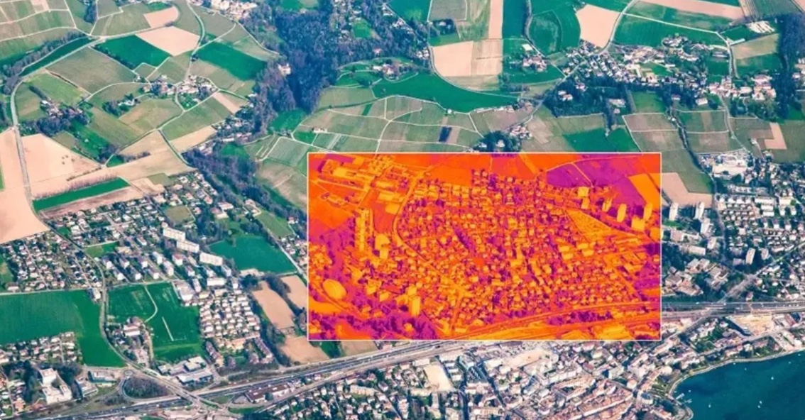
Implementation case — Tumakuru, Karnataka
The operational efficacy of this approach was demonstrated in Tumakuru (Tumkur), Karnataka — a rapidly expanding Tier-2 city facing rising temperatures and solid waste pressures. The city’s landfill spanned nearly 40 acres, making comprehensive manual monitoring impractical. SatLeo deployed satellite-based thermal mapping complemented by drone-mounted infrared sensors to generate high-resolution heat signatures across the waste site and adjacent urban zones.
The intervention revealed concentrated thermal pockets within landfill areas, indicating zones of active decomposition and potential gas accumulation. Simultaneously, the mapping identified distinct urban heat islands in industrial corridors and densely built neighbourhoods. Equipped with this granular visibility, municipal authorities shifted from periodic inspection to targeted intervention. Plantation drives were strategically directed toward heat-intensive zones rather than implemented uniformly. Waste management teams prioritised high-risk landfill segments for mitigation, reducing the probability of fires and uncontrolled emissions.
This data-driven model strengthened administrative efficiency by enabling city officials to allocate limited manpower and financial resources with precision. The approach also improved environmental risk governance by transforming previously invisible temperature dynamics into measurable, actionable intelligence. The Tumakuru case illustrates how satellite-AI integration can compress response timelines, reduce health exposure risks, and enhance municipal preparedness during peak summer periods when heat-related morbidity intensifies.
Scalability and cross-sector applications
Beyond urban waste and heat management, the scalability of thermal intelligence is significant. In agriculture, early detection of crop stress through abnormal surface temperatures can support precision irrigation and drought mitigation strategies. In disaster management, thermal monitoring can aid wildfire detection, infrastructure stress assessment, and flood preparedness by analysing soil moisture and surface heat variations. The same analytical framework can be extended to industrial compliance monitoring and peri-urban ecological assessment.
Strategic relevance — Strengthening climate action and environmental security
At a systemic level, SatLeo’s model demonstrates how frontier space technology can directly advance climate adaptation, mitigation, and environmental security. By embedding early-warning capabilities within urban governance, such platforms contribute to reducing greenhouse gas emissions, preventing secondary disasters like landfill fires, and protecting vulnerable populations disproportionately exposed to heat stress. In a country where climate risk intersects with public health, food security, infrastructure resilience, and economic productivity, thermal intelligence offers a strategic multiplier.
As India advances toward climate-resilient urbanisation and net-zero ambitions, technologies that integrate satellite sensing, AI analytics, and local administrative workflows will be critical. Initiatives like SatLeo exemplify how indigenous space-tech innovation can strengthen climate action, enhance disaster preparedness, and build safer, more secure cities — transforming environmental risk management from reactive firefighting into anticipatory, evidence-based governance at national scale.
Share Your Story Today, Shape Viksit Bharat Tomorrow
Got an idea, innovation, or experience that's making a difference? Share your story now and ignite India's transformation because your voice can drive the future forward!
Resources to Replicate This Idea
BUILD YOUR OWN
Do you want to know how this innovator scaled their idea, how much it cost them, and what resources/partnerships they deployed?
Click here.
Handpicked stories tailored just for you
Explore stories that inspire, inform, and ignite new ideas across tech, innovation, and real-world impact

AI-Enabled Gynaecological Care Expands Access to 400,000+ Women Across India
Pinky Promise is a chat-first, AI-assisted women’s healthcare platform delivering affordable, confidential gynaecological care at scale. Founded in 2022, it...
Read More