Satellite Technology Is Reshaping Agriculture, Cities, and Disaster Response
After the the 2001 Gujarat earthquake, this indigenous satellite infrastructure is making Earth observation more accessible for agriculture, disaster management, and sustainable development.
Updated on: 19 July 2026

Sector

Solution

Technology

State of Origin
Disclaimer:
Features ‘as is’ submissions and neither constitutes endorsement, certification, recommendation, or validation by NITI Aayog nor makes NITI Aayog liable in any manner.
Impact Metrics
End-to-end satellite infrastructure
Dhruva Space designs, builds, integrates, launches, and operates satellites through a single ecosystem, including spacecraft platforms, launch integration, mission operations, and ground stations.
Disaster communication when conventional networks fail
during earthquakes, floods, cyclones, and other disasters when terrestrial networks are disrupted.
Indigenous satellite technology for multiple sectors
support disaster response, climate monitoring, communications, agriculture, scientific research, and national security through a single space ecosystem.
Enabling wider access to satellite technology
for institutions, startups, and government agencies.
When Sanjay Nekkanti witnessed the devastation caused by the 2001 Gujarat earthquake and saw how the collapse of communication networks slowed rescue efforts, it stayed in his mind.
The role of HAM radio operators (which were not reliant on commercial cellular networks or the internet) during the crisis sparked his belief that space-based technology could help keep people connected during emergencies.
Years later, this idea became Dhruva Space, a Hyderabad-based space startup building satellites and ground infrastructure for disaster response, climate monitoring, communications, agriculture, and national security.
Founded in 2012, Dhruva Space is creating an end-to-end space ecosystem right from satellite design and manufacturing to launch integration, mission operations, and ground stations. Its technologies enable faster disaster assessment, environmental monitoring, better decision-making, and expanded connectivity. The company also aims to strengthen India’s space industry through indigenous manufacturing, supplier networks, and training future engineers, helping position India as a global space technology hub.
At the core of its work are spacecraft platforms, which form the main structure of a satellite and carry mission equipment such as cameras, sensors, communication payloads, and other instruments. The company also develops space-grade subsystems, including the satellite’s power systems, onboard computers, communication equipment, and navigation controls. These systems are engineered to function in the extreme conditions of space.
A satellite’s journey does not end after launch. Dhruva Space provides launch integration services, preparing satellites for deployment by securely attaching them to launch vehicles, conducting final checks, and ensuring they are ready for their mission. Once satellites reach orbit, mission operations teams continuously monitor their performance, track their movement, communicate with them, and send commands to ensure they continue functioning as planned.
Another important part of this infrastructure is ground stations — Earth-based antenna systems that maintain communication between satellites and teams on the ground. These stations receive the data collected by satellites and transmit instructions back to them, creating the essential connection between space and Earth.
Dhruva Space’s technology is designed to support applications where satellite data can help solve real-world challenges. Its satellites and infrastructure enable disaster management, climate and environmental monitoring, communications, scientific research, agriculture, and national security applications.
For disaster response, satellites can provide information during floods, earthquakes, cyclones, and wildfires by capturing images of affected areas, identifying accessible routes, assessing damage, and helping authorities understand situations when ground access is difficult. The same Earth observation capabilities can also be used to monitor forests, rivers, glaciers, coastlines, and agricultural land over time.
By bringing spacecraft platforms, satellite components, launch support, mission operations, and ground infrastructure together, Dhruva Space is creating a single system that allows organisations to design, build, launch, and operate satellites through one integrated platform.
Building India’s space infrastructure for multiple missions
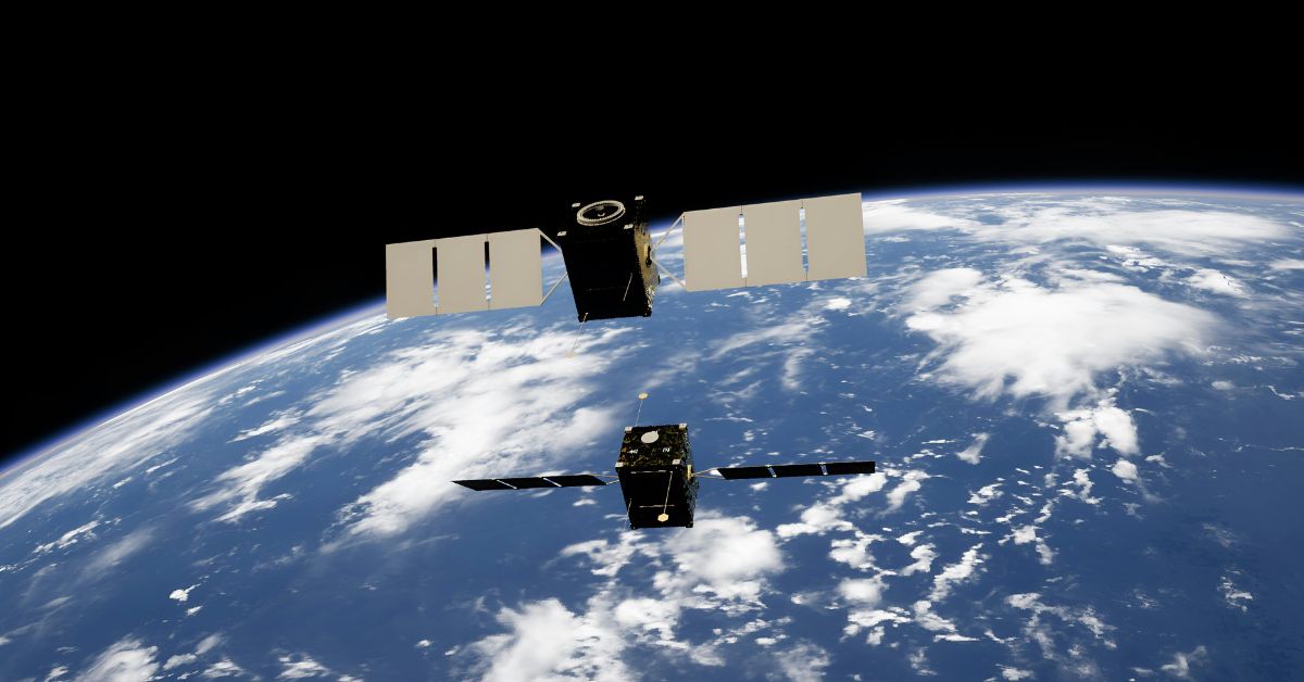
Dhruva Space’s Polar Access-1 (PA-1) marks the company’s most integrated space infrastructure mission, designed to provide structured and repeatable access to Sun-Synchronous Orbit (SSO).
Launched aboard ISRO’s PSLV-DL-C62, the mission brings together satellites, deployment systems, ground stations, and mission operations infrastructure to enable 10 space missions serving six Indian states and two nations.
As part of PA-1, Dhruva Space delivered a coordinated, space-qualified stack consisting of four satellites, five separation systems for in-orbit spacecraft deployment, and multiple ground stations. The mission was built using the company’s full-stack capabilities, including in-house satellite platforms, launch vehicle integration, separation systems, and Ground-Station-as-a-Service (GSaaS) infrastructure.
The mission supports a range of applications including disaster communication, environmental monitoring, education, and commercial Earth observation. Several missions onboard PA-1 represent first-of-their-kind space initiatives for institutions and regions across India.
In Nepal, Dhruva Space enabled an Earth Observation and technology demonstration satellite developed by the Nepal Academy of Science and Technology and Antarikchya Pratisthan Nepal. The mission focuses on vegetation density mapping for environmental monitoring.
In Odisha, CGUSAT-1, developed with CV Raman Global University, becomes one of the state’s first satellite missions. Built on Dhruva Space’s P-DoT satellite platform, it demonstrates store-and-forward communication capabilities designed for disaster response scenarios.
Karnataka’s DSAT-1, developed with Dayananda Sagar University, focuses on two-way amateur-band communications and telemetry, while LACHIT-1, developed with Assam Don Bosco University, represents one of the first satellite missions from India’s Northeast region. These university-led missions are part of Dhruva Space’s ASTRA programme, which aims to build long-term space technology capabilities through hands-on satellite engineering, mission operations, and campus-based ground infrastructure.
Beyond launching satellites, PA-1 focuses on building operational space capabilities. Through collaborations with universities and the National Institute of Amateur Radio, Dhruva Space is conducting training programmes on satellite communications, disaster response applications, and mission operations. By combining spacecraft platforms, deployment systems, ground infrastructure, and operational expertise, Polar Access-1 aims to make space technology more accessible while strengthening India’s private space ecosystem.
But the larger question is how can the observations benefit those on the ground?
Agricultural applications of satellite data
An article published by NASA (National Aeronautics and Space Administration) spotlights the implications that data relayed by satellites could have on India’s agriculture, which supports the livelihoods of around 590 million people.
While acknowledging that understanding agricultural productivity at the farm level has remained challenging because most Indian farms are small — often less than two hectares — and traditional census data usually provides information only at state or national levels, the article underscores the role of satellite-based remote sensing in helping researchers overcome this challenge by providing detailed insights into farmland, crop health, and productivity.

In a study conducted by researchers at the University of Michigan’s School for Environment and Sustainability, where satellite data was used to study agricultural patterns and identify ways to improve crop yields, it was found that “the impact of agricultural interventions could be doubled by using satellite data”.
By combining information from multiple remote sensing systems, researchers can monitor farms at a much finer scale than traditional methods allow.
In 2017, principal researcher of the study Meha Jain developed a method to map winter-cropped areas across India using data from NASA’s Landsat satellites and the Moderate Resolution Imaging Spectroradiometer (MODIS) aboard NASA’s Terra satellite. Landsat provided detailed 30-metre resolution imagery, while MODIS data helped track vegetation health through the Enhanced Vegetation Index (EVI), which measures the greenness and productivity of plants. This created a dataset showing winter crop coverage across India from 2001 to 2016.
The satellite-based dataset helped researchers understand how environmental challenges could affect agriculture. By combining crop maps with irrigation data, Jain’s research found that India could lose around 20 percent of its winter crop production nationally if farmers in areas with severely depleted groundwater lost access to these water sources.
Satellites are also being used to identify ways to close yield gaps, which are differences between the crop production farmers currently achieve and what is possible under local conditions. One major challenge for wheat farmers in parts of India is inefficient nitrogen fertiliser use. Traditionally, many farmers spread fertiliser manually, which can lead to uneven distribution.
Jain and her colleagues studied the impact of mechanical fertiliser spreaders in Bihar, where they compared fields using traditional methods with fields using the machines. Direct crop measurements showed that mechanical spreaders increased wheat yields by about 4.5 percent.
To expand this research beyond individual farms, the team developed a model using satellite imagery from commercial small satellites. These high-resolution images captured crop characteristics such as green chlorophyll levels, allowing researchers to estimate yields across larger areas and identify farms with lower productivity.
The study found that using satellite data to target low-performing farms made interventions more effective. Farmers using mechanical spreaders in identified low-yield areas experienced yield improvements twice as large as those using the technology without satellite-based insights.
This research demonstrates how satellite technology can transform agriculture by helping identify challenges, improve resource use, increase farmer incomes, and support more sustainable food production. By turning images from space into actionable information, satellites are becoming an important tool for building a more efficient and resilient agricultural system in India.
How can Dhruva Space’s models boost development across India’s sectors?
As India’s cities expand rapidly, managing urban growth requires accurate, real-time information about land use, infrastructure, climate risks, and resource availability. Dhruva Space’s development of indigenous satellite platforms, mission operations, and ground infrastructure could play an important role in making satellite-based insights more accessible for urban planning and decision-making.
One of the biggest applications could be in urban mapping and infrastructure development. Earth observation satellites can provide updated imagery of cities, helping planners monitor changes in land use, track construction patterns, identify unauthorised development, and plan roads, housing, and public infrastructure based on changing urban needs. This can support more efficient city expansion and evidence-based planning.
Satellite data can also strengthen disaster preparedness in rapidly growing urban areas. Indian cities are increasingly vulnerable to floods, heat waves, cyclones, and other climate-related risks. Space-based monitoring can help authorities identify flood-prone zones, assess damage after disasters, track changing coastlines, and coordinate emergency responses when ground access is limited. Dhruva Space’s focus on disaster communication infrastructure could further support connectivity during situations when conventional networks fail.
Environmental monitoring is another area where satellite technology can contribute. Cities can use Earth observation data to monitor air quality, shrinking water bodies, urban heat islands, forest cover, and changes in ecosystems. This information can help governments design climate adaptation strategies and manage natural resources more effectively.
Satellite-enabled insights could also improve sectors such as agriculture around expanding urban regions, water management, and transportation planning. Monitoring changes in agricultural land, water availability, and population growth patterns can help policymakers balance urban expansion with environmental sustainability and food security.
By building complete space infrastructure, Dhruva Space is helping strengthen India’s ability to generate and use its own space-based data. As these capabilities scale, satellite technology could move beyond scientific and defence applications to become a foundational tool for smarter cities, enabling governments and institutions to make faster, more informed decisions about India’s future urban development.
Sources:

Share Your Story Today, Shape Viksit Bharat Tomorrow
Got an idea, innovation, or experience that's making a difference? Share your story now and ignite India's transformation because your voice can drive the future forward!
Disclaimer:
Features ‘as is’ submissions and neither constitutes endorsement, certification, recommendation, or validation by NITI Aayog nor makes NITI Aayog liable in any manner.
Resources to Replicate This Idea
BUILD YOUR OWN INTERVENTION
Handpicked stories tailored just for you
Explore stories that inspire, inform, and ignite new ideas across tech, innovation, and real-world impact


AI at the Edge: Transforming Fall Detection Into Lifesaving Protection for the Elderly
Sightica Pro combines multimodal AI, computer vision and audio intelligence to detect falls among elderly and visually impaired individuals, enabling...
Read More