How AI and Satellite Innovation Are Transforming Agriculture for 15 Lakh Farmers Across Haryana
From satellite imagery and AI-powered analytics to drone mapping, frontier technologies are transforming how India monitors crop health, predicts yields and manages agricultural resources. A technology is taking this innovation to scale, using geospatial intelligence to support over 15 lakh farmers across more than one crore agricultural fields and land parcels.
Updated on: 16 November 2026

Sector

Solution

Technology

State of Origin
Disclaimer:
Features ‘as is’ submissions and neither constitutes endorsement, certification, recommendation, or validation by NITI Aayog nor makes NITI Aayog liable in any manner.
Impact Metrics
15 lakh+ farmers
supported by Haryana’s satellite-powered agricultural technology platform.
1 crore+ agricultural fields
and land parcels across Haryana are covered by the system, enabling large-scale crop monitoring and resource management.
4,000+ users
use the platform to access geospatial data for agricultural planning, crop monitoring and informed decision-making.
₹300–400 crore annually
estimated savings to the state through improved yield estimation and procurement planning.
Farmers often struggle to plan crop patterns because of unpredictable weather conditions and changing climatic patterns. Uncertain monsoon arrivals, irregular rainfall, prolonged droughts, sudden floods and rising temperatures make it difficult to decide which crops to sow and when. A crop that requires substantial rainfall may fail if the monsoon is delayed, while unexpected heavy showers can damage standing crops and reduce yields.
These uncertainties also affect irrigation requirements, soil moisture and pest outbreaks. Without reliable, localised weather forecasts and timely agricultural advisories, farmers risk investing in unsuitable crops, losing income and exhausting valuable resources. AI-powered weather prediction and satellite-based monitoring can help address these challenges.
AI-powered analytics that’s bringing technology closer to farmers
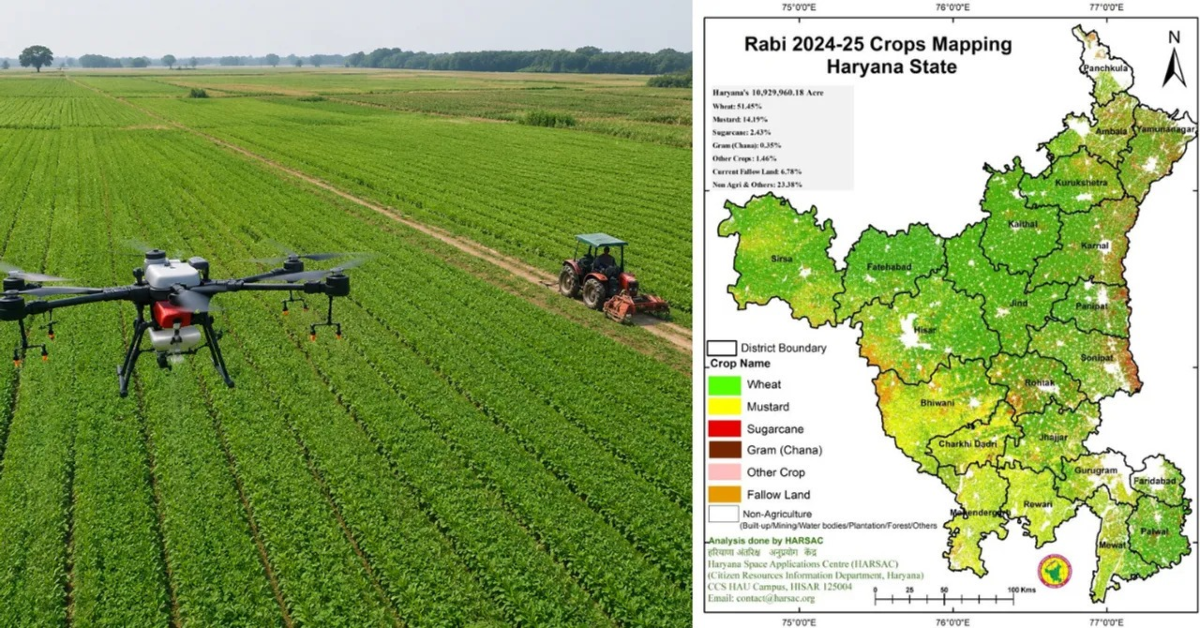
Haryana’s Space Applications Centre (HARSAC) uses a combination of satellite technology, remote sensing, Geographic Information Systems (GIS), drones and Artificial Intelligence (AI) to make agriculture more precise and sustainable.
The system collects satellite images of agricultural fields and analyses them using vegetation indices such as the Normalised Difference Vegetation Index (NDVI). These indicators help measure crop health, vegetation growth and moisture levels, allowing officials to identify water stress and possible nutrient deficiencies before they become visible to farmers.
GIS dashboards bring this information together in detailed field-level maps, while mobile applications make the data accessible to government officials and agricultural planners. Unmanned Aerial Vehicles (UAVs), commonly known as drones, provide additional ground-level information to support monitoring and assessment.
AI-powered analytics help process large volumes of data, assess crop conditions, estimate yields and identify areas requiring intervention. The technology also uses satellite imagery to detect crop residue burning, generating GPS-based alerts that enable officials to respond quickly.
By integrating these technologies into a single platform, HARSAC enables data-driven decisions on irrigation, crop insurance, agricultural planning and resource management. Most importantly, it brings advanced space technology closer to farmers, helping reduce resource wastage, improve productivity and strengthen climate resilience.
The project currently supports more than 15 lakh farmers and covers over one crore agricultural fields and land parcels across the state.
India’s strides towards AI in agriculture
India is increasingly leveraging Artificial Intelligence (AI), satellite remote sensing and geospatial technologies to improve agricultural forecasting, crop insurance and farm management. The Ministry of Agriculture and Farmers’ Welfare is funding two major crop production forecasting initiatives: FASAL (Forecasting Agricultural output using Space, Agro-meteorology and Land based observations), which monitors field crops, and CHAMAN (Coordinated Horticulture Assessment and Management using geo-iNformatics), which assesses horticultural crops. Developed with significant methodological support from ISRO, both programmes are now being operationalised by the Mahalanobis National Crop Forecast Centre (MNCFC).
FASAL monitors nine crops, including rice, wheat, cotton, sugarcane and pulses, while CHAMAN assesses seven horticultural crops, including potato, onion, tomato, mango, banana and citrus. Satellite-based estimates help the government make decisions regarding storage, pricing and international trade.
Under the Pradhan Mantri Fasal Bima Yojana (PMFBY), satellite remote sensing is being used for smart sampling of Crop Cutting Experiments (CCEs), yield dispute resolution and direct yield estimation. The government is also conducting large-scale pilot studies to replace conventional CCE-based assessments with technology-driven yield estimation. These trials have covered multiple states, districts and crops since 2019.
Additionally, initiatives such as KISAN have evaluated satellite-based yield estimation. India is exploring AI and geospatial applications in drought assessment, crop-loss monitoring, pest and disease detection, precision farming, soil mapping, horticulture development and climate-resilient agriculture. Together, these efforts aim to make agricultural decisions more accurate, timely and data-driven.
The geospatial technology supporting India’s goals
Haryana Space Applications Centre (HARSAC), established in 1986 and operational since 1988, plays an important role in advancing India’s use of geospatial technology in agriculture and governance. Its expertise in Remote Sensing (RS), Unmanned Aerial Vehicle (UAV) mapping and Geographic Information Systems (GIS) provides a strong technological foundation for integrating Artificial Intelligence (AI) into agricultural decision-making.
HARSAC develops GIS databases, digital maps and customised software solutions, while using photogrammetry and laser technologies for large-scale mapping. These capabilities allow satellite imagery, drone surveys and geographical information to be converted into detailed, actionable datasets. When combined with AI and data analytics, these datasets can help monitor crop health, assess soil and water resources, estimate yields, identify crop losses and detect environmental changes.
This complements national initiatives such as FASAL and CHAMAN, which use satellite-based observations and geospatial information for crop production forecasting. Similarly, under the Pradhan Mantri Fasal Bima Yojana (PMFBY), remote sensing and technology-based assessments are helping improve crop yield estimation and insurance processes.
HARSAC’s mission of embedding GIS into governance and decision-making also aligns with India’s broader ambition to make agriculture more data-driven. By strengthening mapping infrastructure, research, technical training and decision-support systems, HARSAC helps create the foundation on which AI-powered agricultural solutions can be developed, scaled and implemented, supporting more efficient resource management and climate-resilient farming.
Artificial Intelligence (AI) can help alleviate farmers’ woes by making agriculture more predictable, efficient and resilient. By analysing weather patterns, satellite imagery, soil conditions and historical crop data, AI-powered systems can provide farmers with timely advice on suitable crop choices, sowing schedules and irrigation requirements.
Predictive tools can identify potential pest attacks, crop diseases and water stress before they cause significant damage, allowing farmers to take preventive action. AI can also improve yield estimation, reduce wastage of fertilisers and water, and help farmers make informed decisions about harvesting and market opportunities. Ultimately, these technologies can lower cultivation costs, minimise crop losses and improve farmers’ incomes.
Share Your Story Today, Shape Viksit Bharat Tomorrow
Got an idea, innovation, or experience that's making a difference? Share your story now and ignite India's transformation because your voice can drive the future forward!
Disclaimer:
Features ‘as is’ submissions and neither constitutes endorsement, certification, recommendation, or validation by NITI Aayog nor makes NITI Aayog liable in any manner.
Resources to Replicate This Idea
BUILD YOUR OWN INTERVENTION
Handpicked stories tailored just for you
Explore stories that inspire, inform, and ignite new ideas across tech, innovation, and real-world impact

Clinic-Grade Rehab at Home: IoT Devices Bring Physiotherapy to 250+ Patients Across India
IoT-enabled rehabilitation devices let physiotherapists remotely control treatments while AI tools and AR games guide patients at home. Priced around...
Read More