
How AI-Ready Tree Mapping and GIS Tech Are Helping Kashmir Fight Ecological Loss
Using GIS mapping, QR-enabled tree identities, and ultrasonography-based diagnostics, Jammu & Kashmir has digitally monitored over 28,500 chinar trees, creating a scalable smart-forestry model for climate resilience, urban ecology management, and heritage conservation in rapidly urbanising regions.
Updated on: 09 May 2026

Sector

Solution
Technology
Other

State of Origin
Impact Metrics
~28000+ trees
geo-tagged and digitally documented by early 2025.
35 ecological and administrative
parameters recorded by each tree’s QR-linked profile currently.
Zero reported cases
of illegal felling of geo-tagged chinar trees between 2021 and early 2025.
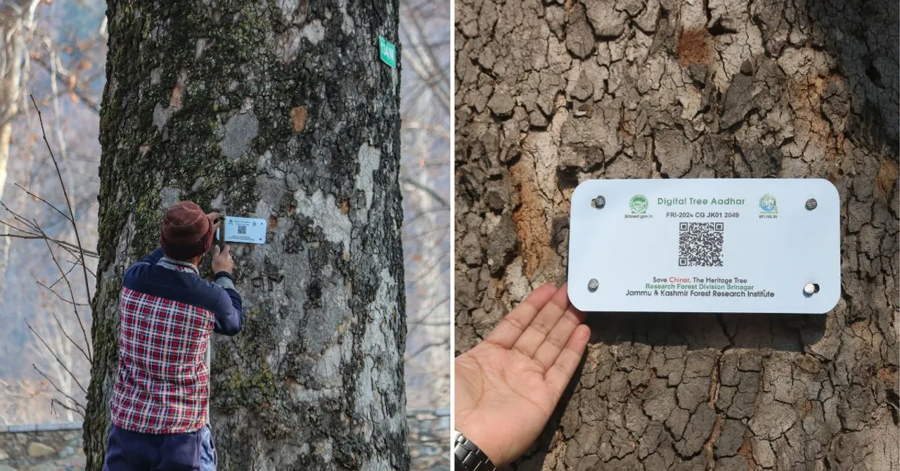
In South Kashmir’s Pulwama district, elderly residents gather around as Forest Department officials attach QR-enabled geo-tags to towering chinar trees. What appears to be a simple tagging exercise is, in reality, the creation of a digital monitoring network for one of Kashmir’s most iconic ecological assets.
The initiative marks a major shift in how urban and heritage trees are being managed in India. Instead of relying on fragmented manual records and reactive conservation measures, Jammu & Kashmir is building a technology-backed ecosystem that can monitor, diagnose, and protect every registered chinar tree in real time.
For a species facing rapid decline due to urbanisation, illegal felling, infrastructure expansion, pest attacks, and climate stress, the project represents a move from symbolic conservation to data-driven environmental governance.
“We can now monitor the health and risk levels of each tree scientifically,” says Syed Tariq, project coordinator at the Jammu and Kashmir Forest Research Institute (JKFRI). “The aim is long-term preservation through continuous monitoring and intervention.”
Why Chinar Trees Matter to Kashmir’s Urban Ecology
Known locally as Bouin, the chinar is deeply woven into Kashmir’s environmental and cultural identity. These trees can take nearly 150 years to reach maturity, grow up to 30 metres tall, and survive for several centuries.
Historically planted during the Mughal and Dogra eras, chinars continue to define the landscape of public gardens, lakesides, shrines, campuses, and urban settlements across the valley. Locations such as Naseem Bagh and Shalimar Garden derive much of their ecological and tourism value from these dense chinar canopies.
But their importance extends beyond aesthetics and heritage.
Environmental experts say chinars function as major carbon sinks, stabilise soil through deep root systems, reduce urban heat, improve air quality, and help mitigate erosion during floods. During the 2014 Kashmir floods, areas with mature chinar cover reportedly experienced significantly lower soil erosion.
For a climate-vulnerable Himalayan region experiencing rising temperatures and declining precipitation, preserving mature tree cover has become both an environmental and urban resilience priority.
From Manual Surveys to Intelligent Tree Infrastructure
The turning point came in 2021, when the J&K Forest Department launched a large-scale geo-tagging and digital census initiative for chinar trees.
The project integrates multiple layers of technology:
GIS-Based Tree Mapping
Every identified chinar tree is being mapped using Geographic Information System (GIS) technology, creating a spatial database of tree locations across Kashmir.
This allows authorities to visualise tree distribution, identify vulnerable zones, monitor density changes, and plan conservation interventions geographically rather than administratively.
In urban development terms, the initiative effectively creates a “green infrastructure layer” that can eventually integrate with land-use planning, road expansion projects, and smart city systems.
QR-Enabled Digital Identity for Trees
Each tagged tree receives a QR-coded metal plate that functions like a digital identity card.
When scanned, the code provides access to a detailed database containing dozens of parameters about the tree, including:
- Geographic coordinates
- Estimated age
- Height and girth
- Health condition
- Pest or disease history
- Ownership status
- Conservation records
- Intervention requirements
This creates traceability and accountability in tree management — something largely absent in conventional forestry systems.
The QR system also reduces dependence on paper-based documentation and enables field officials, researchers, and administrators to access live records instantly.
Ultrasonography-Based Health Diagnostics
One of the project’s most advanced components is the use of ultrasonography-based (USG) diagnostic devices to assess internal tree health.
Traditionally, tree health inspections relied heavily on visual assessments, which often failed to detect internal decay until it became irreversible.
The USG system changes that by enabling non-invasive internal diagnostics. Officials can identify structural weaknesses, fungal infections, hollow trunks, and decay risks early enough for preventive treatment.
The approach mirrors predictive maintenance systems used in industrial infrastructure and smart utilities — but applied to urban ecology.
Building a Data-Driven Conservation System
According to officials associated with the project:
- Around 28,500 chinar trees had been geo-tagged by early 2025
- The number is expected to reach 32,500 by March 2025
- Another 10,000 trees are planned for inclusion in the next phase
- Each tree record currently captures roughly 35 ecological and administrative parameters
The long-term objective is to build a continuously updated ecological intelligence system for Kashmir’s heritage trees.
Instead of conducting isolated plantation drives or emergency interventions after tree decline, authorities aim to use longitudinal data to predict risks, prioritise treatment, and monitor ecological change over time.
This transforms conservation from a reactive activity into an operational management system.
The Urban Development Relevance
Although positioned as a conservation initiative, the project has major implications for urban development and climate-resilient planning.
1. Integrating Trees Into Urban Infrastructure Planning
Indian cities often lose mature trees during road widening, real estate expansion, and utility projects because tree inventories are incomplete or outdated.
A GIS-linked tree database creates visibility for planners and regulators before infrastructure approvals are granted.
Such systems could eventually integrate with municipal digital twins, smart city dashboards, and environmental impact assessments.
2. Climate Resilience and Heat Mitigation
Large canopy trees play a measurable role in reducing urban heat island effects, retaining groundwater moisture, and improving air quality.
Digitally monitored urban forestry systems can help cities identify high-risk heat zones and prioritise green cover protection strategically rather than symbolically.
3. Heritage Preservation Through Civic Tech
Many Indian heritage trees disappear because no official ownership, identity, or monitoring framework exists.
The QR-tagging model effectively converts ecological heritage into administratively recognised infrastructure assets.
This creates stronger legal accountability against illegal felling and improves monitoring transparency.
4. Scalable Environmental Governance
The system demonstrates how emerging technologies — GIS, QR databases, remote diagnostics, and environmental data systems — can modernise governance without requiring extremely high-cost infrastructure.
The model is particularly relevant for states managing:
- Heritage trees
- Urban forests
- Wetlands
- Biodiversity corridors
- Riverfront ecosystems
- Climate adaptation zones
Early Outcomes and Impact
While the project’s long-term ecological assessment is still underway, officials say the initiative has already strengthened enforcement and monitoring capabilities.
According to project coordinators, no illegal felling of geo-tagged chinar trees has been reported between 2021 and early 2025.
The database is also enabling more targeted maintenance interventions and helping researchers identify trees requiring treatment before irreversible decline occurs.
Equally important is the creation of institutional memory. Earlier, conservation records often depended on local knowledge or disconnected paperwork. The new system centralises ecological intelligence into a permanent digital archive.
A Scalable Blueprint for Indian Cities
The Kashmir chinar project offers a glimpse into what urban ecological governance could look like in the future.
As Indian cities confront worsening heat stress, biodiversity loss, flooding, and shrinking green cover, environmental infrastructure will increasingly require the same level of digital management already used for roads, utilities, and transport systems.
The geo-tagging initiative demonstrates that trees can be treated not merely as ornamental landscape elements, but as measurable, monitorable public assets.
Its scalability lies not only in the technology itself, but in the governance architecture it introduces — one where ecology, urban planning, climate resilience, and digital infrastructure operate together rather than in silos.
Share Your Story Today, Shape Viksit Bharat Tomorrow
Got an idea, innovation, or experience that's making a difference? Share your story now and ignite India's transformation because your voice can drive the future forward!
Resources to Replicate This Idea
BUILD YOUR OWN
Do you want to know how this innovator scaled their idea, how much it cost them, and what resources/partnerships they deployed?
Handpicked stories tailored just for you
Explore stories that inspire, inform, and ignite new ideas across tech, innovation, and real-world impact

From Smart Cow Collars to Carbon Credits: How AI Is Transforming Dairy Farming for 22 Lakh Farmers Across India
From AI-powered smart cattle collars and precision breeding tools to methane reduction programmes and carbon credit generation, eVerse.AI is transforming...
Read More